- +91 353 2527576
- [email protected]
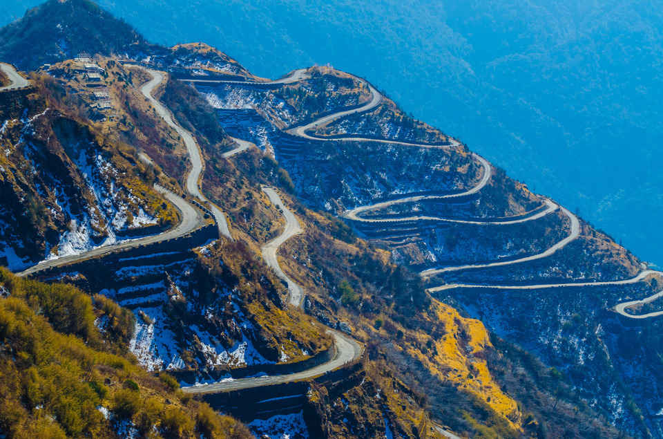
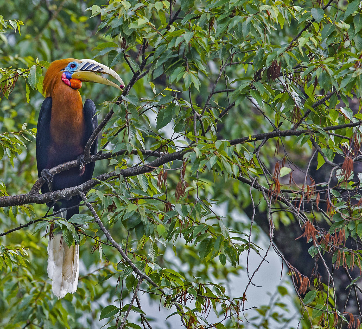
Meghalaya is the 21st state of India declared on 21 January 1972. Literally means the 'Abode of the Clouds'. It is a region of great scenic beauty; a panorama of lush, undulating hills, meandering rivers, waterfalls, streams and lakes. It united the areas of the Khasi, Jaintia and Garo Hills. The State is divided into three hilly regions-the Garo Hills i.e. Western Meghalaya, the Khasi Hills i.e. Central Meghalaya and the Jaintia Hills i.e. Eastern Meghalaya. Travelers can come across villagers competing in archery as it is one of the sport and competitions are held regularly in most villages. The forests are known for its biodiversity. The flora and fauna found here are unique to the state like the mammals, birds, and plants. Meghalaya is a peaceful state with minimum crime rate. Traveler will come across churches, temples, mosques, gurudwara and monastery etc. People of the state are hospitable, colorful, god fearing and are religious minded. They participate in their festivals which themselves draw lots of visitors. Meghalaya is also known as the adventure for caving.

The Major airport nearest to Meghalaya is Guwahati. Guwahati has direct flights available from Kolkata, Delhi, Bagdogra, etc. Guwahati airport is one of the busiest airports in north east India.It has link to the rest of the country and with Bangkok. The other airport of the state is at Umroi in Meghalaya. It is only 35 kilometers from Shillong.There is a regular helicopter service from Guwahati Airport to Shillong and can be booked well in advance.

This is one of the states in India where till date the Indian rail has not spread its wing. Practically there is no railway system in Meghalaya. Like airport the nearest major railhead is at Guwahati. It is situated at a distance of 103 kilometers from Shillong. In other words Guwahati is the only town in north east India which is well connected with the rest of the country by broad gauge railways, roadways and airways.

Shillong is connected by roads to Guwahati, Silchar and Garo Hills. Rergular bus service is available from Guwahati. These are generally small utility vehicle like Tata Sumo & Mahindra Bolero etc. These vehicles can be shared between 8 people or can be hired by one. It is approximately three hours drive to reach Shillong from Guwahati. Private vehicles are also available. Baghmara (Via Tura) is 445 kilometers, Cherrapunjee / Sohra 49 is kilometers, Mawkyrwat is 74 kilometers, Jowai is 66 kilometers Nongstoin is 93 kilometers, Nongpoh is 53 kilometers, Shella is 93 kilometers, Mawsynram is 58 kilometers, Mawkynrew is 46 kilometers, Mawryngkneng is 37 kilometers, Umling is 70 kilometers, Tura is 323 kilometers, Williamnagar is 312 kilometers, Umsning 30 is kilometers, and Mawphlang is 24 kilometers from Shillong.
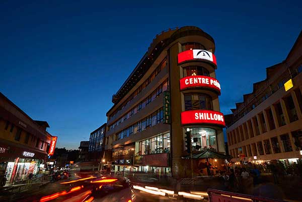
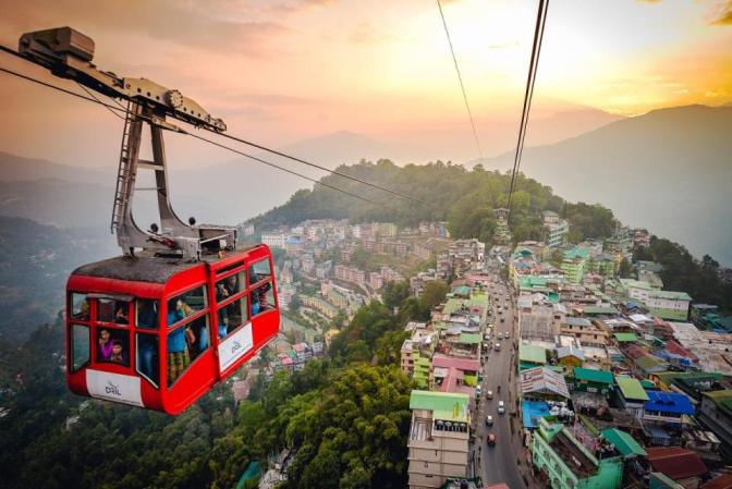
It is one of the most beautiful hill stations in north east India. It is the capital city of the Meghalaya State as well. Shillong is the districts headquarter of East Khasi Hill District. Shillong is a major tourist attraction today. Due to its geographical location and elevation, it experiences sub - tropical climate with mild summers and chilly to cold winters and the Cherrapunjee belt receives the highest rainfall in the world. Shillong also experience / receives heavy rainfalls during monsoon. October to April is the best season to visit Shillong. It has one of the largest and natural golf courses in Asia. Shillong is scenic and enjoyable, it is also offers its visitors all the charms of tourism. The people of Shillong are cheerful, hospitable, peaceful and social, something reflected in their music, dance and sports. There are a few festivals held in Shillong with much fun fare. There are a few Churches and Cathedral and some of these are so spacious and large that they can be easily accommodating a few thousand worshippers.
Airways : The nearest airport is at Umroi nearly 30 minutes drive to Shillong. At Shillong there are direct flights available only from Kolkata. The nearest major airport is Guwahati. There are flights available from Kolkata, Delhi, and Bagdogra. Also available are helicopter service from Guwahati Airport to Shillong, information and tickets available at the Helicopter Counter in the airport.
Railways : There are no rail lines in Meghalaya. The nearest Railway station is the Guwahati Railway Station 110 kilometers from Shillong. Guwahati is well connected with the rest of the country by broad gauge railway.
Roadways : Meghalaya Transport Corporation and Assam State Transport Corporation buses are available, frequently plying from Guwahati to Shillong, Silchar and Garo hills. Private vehicles like Tata Sumo & Mahindra Bolero is available and can also be shared. It takes nearly 3 hours to reach Shillong from Guwahati. Private vehicles are also available. Some of the distances of places in north east are Itanagar is 406 kilometers, Dispur in Guwahati is 103 kilometers, Imphal is 576 kilometers, Aizwal is 415 kilometers, Kohima is 434 kilometers and Agartala is 662 kilometers.
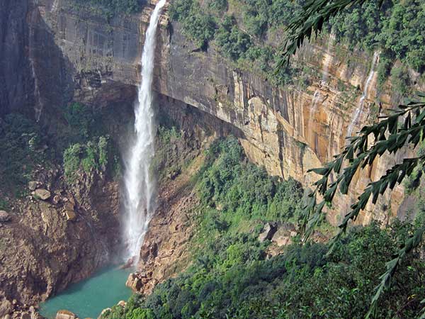
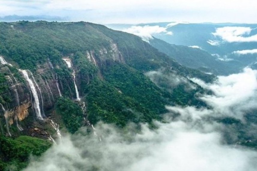
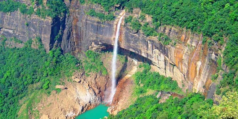
Cherrapunjee is also known as the Scotland of the East, locally and officially known as Sohra. It was the headquarters of the Khasi / Jaintia province during British rule which was however shifted to Shillong in 1864. It is one of the most developed trading centers in the Khasi Hills. It is also the wettest region of the world with some breathtaking waterfalls. The average rainfall is 12,000 millimeters a year and the record for a single day was 2455 millimeters recorded in 1974 confirming it as the wettest place on Earth. A large variety of spices, flowers, medicinal plants and mushrooms are also grows in the in this region. The drive from Shillong to Cherrapunjee is 60 kilometers and one hour drive, the beautiful waterfall Nohkalikai is at Cherrapunjee. Caving is an important part of Meghalaya and Cherrapunjee explore some of the caves in and around Cherrapunjee.One of the most used packages by tourist is Shillong - Cherrapunjee - Kaziranga - Kohima - Touphema - Dimori Cove - Jorhat - Majuli – Guwahati.
Airways : Helicopter service- information and tickets are available at MTC bus stand in Shillong and from Shillong its 60 kilometers drive to Cherrapunjee. Nearest Major Airport is Guwahati at a distance of nearly 230 kilometers. Guwahati is well connected with the rest of India and there are regular flights to Delhi, Kolkata and other places of India. Helicopter service is also available from Guwahati Airport rest of north East Indian tourist towns and to Tura via Shillong.
Railways : As there is no railways at Meghalaya and one has to reach the nearest major railhead at Guwahati. Guwahati is at a distance of nearly 230 kilometers from Tura and is well connected with the rest of the country.
Roadways : It is 60 kilometers from Shillong and approximately 230 kilometers from Guwahati. Private Night Bus service counters are in Police Bazaar and the Buses are parked in Polo Grounds in Shillong. It is 325 kilometers and overnight journey from Shillong by road. There are two Tourist Taxi Stands in Police Bazaar area where a selection of taxis can be hired from Shillong. The distance to Shillong via Guwahati is bit less. Private vehicles are available. Baghmara is 122 kilometers, Resubelpara is 88 kilometers, Dadengiri is 54 kilometers, Zikzak is 51 kilometers, Rongram is 15 kilometers and Chokpot is 53 kilometers.
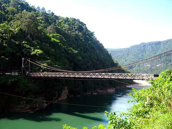
The most important town in the Jaintia Hills district is Jowai situated at an elevation of nearly 1,380 metres, and at a distance of nearly 70 Kilometers from Shillong. Annual festival of Behdeinkhlam is celebrated in great fun fare in Jowai. The journey from Shillong to Jowai is mesmerizing. The scenic beauty along the route by road is grassy meadows, meandering Myntdu River, colorful graveyards, rice terraces and woods of oak or pine. It is a picturesque urban settlement at a distance of 65 kilometers to the eastern side of the popular hill station, Shillong. It is situated at an elevation of nearly 1400 meters. It offers its visitors natural glaze and a placid ambiance. Jowai is the coveted headquarters of the Jaintia district and the tribes are under the impression that they are the successors of the mighty Mongolians. Since, Jowai in Meghalaya is situated at a stone's throw from the enthralling tourist hub, Shillong; it can be accessed by buses that leave for Silchar. The grandeur is enhanced by the presence of the Myntdu River and an artificial lake known as Thadlaskein Lake where one can take the pleasure of boating.
Airways : The nearest airport is at Jowai is nearly 70 kilometers drive to Shillong and 170 kilometers from Guwahati. At Shillong, there are direct flights available only from Kolkata. The nearest major airport is Guwahati. There are flights available from Kolkata, Delhi, and Bagdogra. Also available are helicopter service from Guwahati Airport to Shillong, information and tickets available at the Helicopter Counter in the airport.
Railways : As there is no railways at Meghalaya and one has to reach the nearest major railhead at Guwahati. Guwahati is at a distance of nearly 170 kilometers from Jowai via Shillong and is well connected with the rest of the country. In other words Guwahati is the only town in north east India which is well connected with the rest of the country by railways, roadways and airways.
Roadways : Jowai is at a distance of 65 kilometers to the eastern side of the popular hill station, Shillong. Most of the places are well connected by Private Buses, Indicas, Tata Sumos, etc. There are also a few State Transport Buses connecting the places. Some of the distances by road from Jowai are Laskein is 35 Kilometers, Thadlaskein is 10 Kilometers, Dawki is 60 Kilometers New Garampani is 67 Kilometers, Khliehriat is 35 Kilometers, Nongstoin is 159 Kilometers, Cherrapunjee is 115 kilometers and Amlarem is 28 Kilometers.
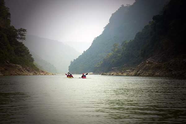
Ranikor is a small town on the border of India and Bangladesh. It is a relatively unexplored land, splendid visions of rows of pine trees, lush hills and quaint cottages will please you. Driving to Ranikor will also take you through the wettest land on earth known as Mausindram. It is one of the best angling spots. The river originates from a town called Rilang and the fishing zone on the river Kynshi is approximately 15 to 16 kilometers from Ranikor. The species of fishes found here are chocolate mahseer, goonch / catfish, eels, golden mahseers, golden carp, silver carp and the common carp. Tourist can even row up the Ranikor river where the Kynshi and Rilang. The sight is picturesque for the fine rock cliffs surrounding the clear water. It’s a place for leisure and adventure tourism. Accommodations available are not too luxurious but are good enough to provide you a perfect comfort. It is a reservoir of horticultural, inhabited by Garo, Khasi, Jaintia Bhoi and War tribes and offers a peaceful atmosphere.
Airways : From Ranikor one has to drive to Shillong nearly 140 kilometers or Guwahati nearly 250 kilometers. The nearest airport is at Umroi nearly 30 minutes drive to Shillong. At Shillong there are direct flights available only from Kolkata. The nearest major airport is Guwahati. There are flights available from Kolkata, Delhi, and Bagdogra. Also available are helicopter service from Guwahati Airport to Shillong, information and tickets available at the Helicopter Counter in the airport.
Railways : The nearest railway station is Guwahati railway station from where you can take a bus to Shillong and from there you can reach Ranikor in bus or taxi. As there are no rail lines in Meghalaya, the nearest Railway station is the Guwahati Railway Station 240 kilometers from Shillong. Guwahati is well connected with the rest of the country by broad gauge railway. State run buses and private vehicles are available for transfer to railway station.
Roadways : Ranikor is about 170 kilometers from Nongstoin and 140 kilometers from Shillong and nearly five hours drive. Guwahati is 250 kilometers from Ranikor. Both Deluxe and ordinary bus services are available. Private vehicles are also available for transfer. Meghalaya Transport Corporation and Assam State Transport Corporation buses are available, frequently plying from Guwahati to Shillong, Silchar and other places of Meghalaya and the frequency is good.
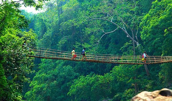
This virgin area is nearly 330 kilometers from Shillong the capital of Meghalaya otherwise known as the abode of clouds also home to the Khasi highland tribes. Tura is situated at an elevation of 657 metres and has a picturesque landscape of hills overlooking the mighty Brahmaputra River. Tura Peak is an ideal place for rock climbers, hikers and naturalists. Nokrek Biosphere Reserve covers an area of about 800 square kilometers and an exciting trekking track is from Nokrek to Tura through the Tura Peak passing through some thick virgin tropical forests before reaching the Tura Peak. Another interesting spot at the confluence of two rivers namely Ganol and Rongram is an Old Stone Age site which is worth visiting. The major circuits of Meghalaya such as Shillong-Jowai, Shillong-Tura and Shillong-Sohra are well developed and in the other areas the conditions of roads are not so developed. Visit to Badadam area is a must, here one can find the Borangs or the original tree houses are a common sight. Tura – Babadam – Nokrek – Tura and Tura – Siju – Balpakram – Baghmara – Tura and Tura – Balpakram – Siju – Shillong – Jowai are some of the popular tour packages in and from Tura. Tura is a place of solace and tranquility and provides the right atmosphere for all adventurer, nature lovers and trekkers. Canopy of thick, tall and lush green forests cover Nokrek.
Airways : Helicopter service- information and tickets are available at MTC bus stand in Shillong. Nearest Major Airport is Guwahati at a distance of nearly 230 kilometers. Guwahati is well connected with the rest of India and there are regular flights to Delhi, Kolkata and other places of India. Helicopter service is also available from Guwahati Airport rest of north East Indian tourist towns and to Tura via Shillong.
Railways : As there is no railways at Meghalaya and one has to reach the nearest major railhead at Guwahati. Guwahati is at a distance of nearly 230 kilometers from Tura and is well connected with the rest of the country.
Roadways : Private Night Bus service counters are in Police Bazar and the Buses are parked in Polo Grounds in Shillong. It is 325 kilometers and overnight journey from Shillong by road. There are two Tourist Taxi Stands in Police Bazar area where a selection of taxis can be hired from Shillong and its approximately 230 kilometers from Guwahati. The distance to Shillong via Guwahati is bit less. Private vehicles are available. Baghmara is 122 kilometers, Resubelpara is 88 kilometers, Dadengiri is 54 kilometers, Zikzak is 51 kilometers, Rongram is 15 kilometers and Chokpot is 53 kilometers.

Ramesh Jain, Delhi
Jegathiswaran, Chennai
Priti Patel, Gujrat